Overview
Length: 16km
Elevation: 819m
Type: Loop
Time: 2hrs 30m
Introduction
Markus and I have climbed the Montgó many times, but always from the Jávea side.
Either from the Camp de Tiro or Jesús Pobre—in fact, Jesús Pobre was where we did our very first trail run. We’d always avoided the Denia ascent. People said it was steep, rocky, and unforgiving, and frankly, it sounded above our level.
But after our recent trip to Tossa de Mar, we felt fitter, motivated, and—let’s be honest—keen to burn off some Christmas weight!
So, we decided to tackle the Denia side at last. The route is a gorgeous loop that includes the Cova de l’Aigua, a fascinating historical site, and a return descent with sweeping views.
About the Montgó from Denia
The Montgó Massif is split between two towns (Jávea and Denia) and both fiercely claim to have the “best side.”
The Jávea side is sunny and vibrant, with red, sunbaked slopes that glow in the afternoon light. The Denia side, by contrast, is often shaded and much greener, with pine forests and hidden treasures like the Cova de l’Aigua and the Benimaquia Iberian ruins.
There’s even a strange local legend about a tug-of-war over the Montgó. The story goes that the people of Denia fell forward on their faces, while the Jávea side landed flat on their backs. What this has to do with the mountain, I’ve never figured out—but if you know, do let me know!
What I do know is that both sides of the Montgó are incredible in their own ways. And while the Jávea side offers easier routes, the Denia ascent is full of surprises, making it well worth the effort.
The Trail Running Route
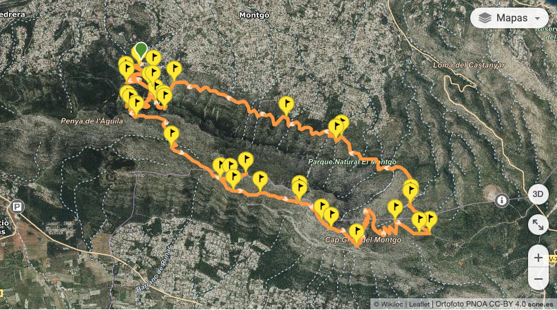
We started the loop trail from the Camí de la Colònia in Denia, where a dirt track begins just past a chain gate. Parking nearby, we set off, quickly leaving behind the chalets and entering the forested slopes.
The first part of the trail is straightforward, leading to a junction where we turned left towards the Cova de l’Aigua.
The Cova de l’Aigua is an ancient water cave with an inscription from 238 AD, left by Roman legionnaires of the VII Gémina. It’s a short detour but absolutely worth it. Standing there, I could almost imagine the soldiers carving those letters into the rock centuries ago (shame about the bloody grafitti!!!).
After backtracking to the main trail, we began the climb to the Montgó’s summit.
This section, heading west along the shaded northern face, was steeper and more technical. At the Barranco de la Penya de l’Àguila, we took the path marked for the summit, leaving the fork to the Racó del Bou behind. From here, it’s a challenging ascent, but the views keep you going.
Before reaching the summit, we passed a sign pointing to the Creu de Dènia (Denia Cross).
At 694 meters, it’s slightly lower than the summit but offers breathtaking views of Denia, Jávea, and the coastline. We made a quick detour to take it in, then returned to the trail to tackle the final stretch.
The summit of the Montgó, at 752 meters, is spectacular. From the top, we could see everything: the Cabo de San Antonio, the towns of Denia and Jávea, and even the Peñón de Ifach and Sierra de Bérnia. On a clear day we’ve seen as far as Mallorca.
But, alas, not today.
For the descent, we chose to complete the loop. Heading east, the trail led us to the Cova del Camell, another intriguing natural feature, before rejoining the Camí de la Colònia.
The descent was rocky and a bit tricky in parts, but the changing scenery—from rugged cliffs to peaceful trails winding through the forest—made it well worth it.
Don’t get me wrong…you’ll feel this one for days.
But it’s one of our favourite routes now. Whenever we’re feeling like a challenge, or have too much food to burn off, this is our new “local”.
Wikiloc route.

Roman-era inscription on the Cova de l’Aigua. And graffiti…grrr.

Incredible views over Denia.
